No amount of superlatives can describe the storm taking shape over the central and northern plains. My projections of surface intensity in the previous post were completely wrong (I believed 966 was too low). With any sort of extreme weather system, any particular dynamic and/or kinematic field is expected to be impressive. This storm, however, is displaying an incredible amount of jet stream divergence which shows up in spectacular fashion on satellite imagery. Let’s take a look.
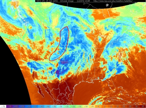
IR satellite image at 15Z with the center of the jet stream noted at 250 hpa with the red line. The green circle denotes the upstream jet streak in excess of 160-180 knots.
12Z 300 hpa analysis with winds and divergence plotted (thanks to http://www.patricktmarsh.com/, I never knew jet stream level winds with divergence plotted existed!):
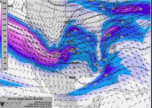
As analyzed by the 12Z GFS @ 18Z (250 hpa):
Note the increasing jet level winds on the eastern side of the upper level trough from 12Z to 18Z. Let’s investigate further.
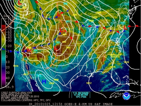
The 12Z HPC surface analysis has the cold front analyzed in northern CO:
Note the well defined lee cyclone in the Front Range of CO extending into New Mexico, an atmospheric response due to the cross-barrier flow blocking effect of the Rockies. Large and long mountain ranges block the otherwise orderly flow of cold air advection, resulting in a geostrophic adjustment process. Lee cyclogenesis acts to enhance the low-level south flow and, in the case of the US, the flow of warm and moist Gulf air northward. The “blocking” of cold air into the plains acts to “displace” the cold air aloft from the low level warm air in the plains in the vertical. Mentioned in the previous post as well, the thermal wind equation comes into play here. http://amsglossary.allenpress.com/glossary/search?id=thermal-wind-equation1
The change in the geostrophic wind with height (vertical shear) is related to the thermal gradient. The jet stream, therefore, is a manifestation of intense baroclinic zones and upper level fronts, not the other way around.
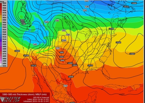
Let us put it together a little more. Take a look at the GFS 12Z analyzed 1000-500 mb thickness fields:
The location of the surface trough is noted with the green line with strong surface ridging behind the front (as expected).
Note that, at 12Z, the upper level cold air isotherm packing is lagging behind the low level cold air:
The effects of large scale flow blocking become much more apparent here as we put things together. The effect of the broad and high Colorado Rockies is to block or retard the low level progression of otherwise orderly cold air advection.
BY 18Z, the region of cold air aloft has now become superimposed over the region of lower level cold air associated with the low level front, currently being blocked by the high terrain of the Rockies.
Oh, but wait. What did the thermal wind equation state? The picture is becoming slightly more clear now. The juxtaposition of cold air aloft and at low levels along with the continued effect of lee cyclogenesis due to cross barrier flow results in southerly warm air advection in the low levels of the high plains. These processes work to enhance the baroclinic zone along the mountain barrier.
18Z GFS forecast shows how much tighter the 1000-500 mb thickness field has become due to the aforementioned processes. Also note the high-low pressure couplet that has developed across CO with the decrease in the surface pressure of the lee cyclone, now to 984 mb. Cold bora winds downslope into the plains as the cold air “pours” over the Front Range.
As expected from the thermal wind equation, our jet stream has now become stronger on the eastward side of the curved jet stream over our now enhanced baroclinic zone across the high plains (circled). :
:
Also worth noting here are some of the terrain flows that can develop under such circumstances. In the case of the Front Range, mesoscale terrain flows can develop around or over regions of decreased height in the Rockies. Extreme pressure gradient forces are relaxed through relatively narrow regions of the terrain, resulting in terrain enhanced gradient forces.
Both the Ferris Mountains and the Laramies reach elevations above 10,000 feet with the Snowy Range (named the Medicine Bows in Colorado) extending to over 12,000 feet. Gaps in the terrain extend down to 7500 feet in Laramie, WY before reaching approximately 4600 feet in Akron, CO. With I-80 along southern WY being the only large scale “outlet” for subsident air over the Great Basin, winds can become rather extreme.
The obs from Akron, CO clearly show frontal passage (boxed red) with the typical pressure falls preceding the front followed by rapid pressure rises. Of course, peak winds occur during the time period of rapid pressure rises (boxed green) and strong descent due to efficient mixing in the convective boundary layer acting in conjunction with descent on the backside of the frontal circulation (circled red).
Let’s move on.
Curved jet dynamics result in regions of strong ascent/descent (ascent on the exit region, descent on the entrance region) on the poleward (cold) side of the jet stream.
Also note the increasing amplitude of the trough and the “digging” nature of the jet. Is this a result of QG Chi interepreted height falls associated with abnormal thermal advection patterns noted earlier? Think about that. Do jets “dig” or do heights fall? I will let the readers decide.
Goes satellite derived WV winds at 18Z suggest both the NAM and GFS are under observing the jet streak winds on the downstream portion of the trough which would result in even greater values of jet divergence. Circled isotach at 120 kts (18Z GFS peaked at 90 kts from 300-200 hpa).
This jet stream divergence was manifested in spectacular fashion on satellite imagery:
And on multi-spectral satellite imagery:
Here is an animation of the cloud patterns associated with this divergence over Colorado. This is the best way to see the divergence pattern and associated cloud field:
Also note the “folds” oriented perpendicular to the flow (easily seen in the visible sat images). Personally, I have no explanation for these features. It seems plausible the N-S oriented CO Rockies have an influence, but I personally have no reasoning. Anyone with ideas or explanations please let me know.
Update: The expected smooth nature of the jet cloud pattern over WY is typical earlier in the day. As the system interacts with the Front Range of Colorado, the folds seem to originate in the region where enhanced vertically propagating mountain waves often develop. This seems like a plausible explanation, but I will have to do more of an analysis before coming to such a conclusion.
This analysis ends here, but note this is just one explanation (also the more simplistic and less mathematical approach and reasoning) of lee cyclogenesis and further baroclinic development associated with an intense jet stream (lee troughing is possible with little to no jet stream/weak baroclinity). Other authors have proposed a QG explanation (Bluestein uses this approach in his Synoptics in Midlatitudes) as well as potential vorticity reasoning. In general, differing “theories” and interpretations seem to come to relatively similar conclusions (in the last 20 years at least).
Meteorology is a beautiful thing when it makes sense.
Additional reading for those interested.
http://journals.ametsoc.org/doi/pdf/10.1175/1520-0493(1989)117%3C0154:NAOTIO%3E2.0.CO;2
http://www.atm.helsinki.fi/~dschultz/pubs/19-SchultzDoswell00.pdf


